Chase Accounts
2008
 |
5/22 Collyer, KS Observed 4 tornadoes across portions of NW Kansas. Scott Blair, Katie Burtis, Al Pietrycha, and I began the day in GLD with an initial target of Scott City, KS. Chased several storms from Scott City to I-70 as they moved north-northeast. Observed the first tornado at 5:28pm, an elephant trunk tornado near Grainfield which persisted for 17 minutes, becoming a long rope as as it dissipation. We observed the next storm south of Collyer. This tornado produced two tornadoes simultaneously at times; a skinny cone with a debris whirl and another tornadic region that evolved from a dust bowl into several condensed tubes. We headed eastbound on I-70 to keep ahead of the storm and stopped to allow a new region of violent rotation pass to the west. The fourth tornado developed just south of I-70 with a near continuous debris whirl underneath intense rotation, occasionally producing a cone beneath the central axis of the wall cloud. We ended the day with dinner in Oberlin, KS meeting up with Magliocco, Fritchie, Currens, Eubanks. |
|
5/23 Randsom/Ellis, KS Katie Burtis and I observed 5 tornadoes near Quinter, Ransom to Ellis. Chased with Scott Blair for most of the day observing the first tornado, a stovepipe which transitioned into a wedge north of I-70 near Quinter. The second tornado developed persisted for approximately 2 min as a narrow cone with small debris whirl southeast of Ransom. The third tornado occurred as the meso began to occlude east of Ransom, with the tornadic region crossing Hwy4 while becoming rain wrapped. We headed east and then north to keep ahead of the storms as a new meso developed. A quarter to half mile wide wedge tornado soon after south of Cedar Bluff State Park. This tornado eventually wrapped in rain and crossed I-70 west of Ellis with numerous power flashed observed. The final observed tornado occurred just south of Ellis with power flashes along the south side of town, eventually forming a narrow cone. |
|
 |
5/24 Douglas, OK Chased
the north-central Oklahoma supercell with Scott Blair, Katie Burtis,
Amos Magliocco, and Scott Eubanks observing 6 tornadoes. We departed
Salina, KS by late morning with a target near the intersection of the
dryline and outflow boundary. We obtained our first visual of the storm
near Bison, OK with a well defined wall cloud quickly developing. An
elephant trunk tornado soon evolved, persisting for apporoximately 5
minutes 6 miles WSW of Douglas. The storm slowly moved east from Douglas
to south of Covington, producing several more tornadoes including a
large cone. Another photogenic tornado developed about 9 miles SW of
Perry and persisted for approximately 10 minutes. Ended the day in Morrison
with a fantastic chicken fried steak dinner. |
|
5/26 Kinsley/Haviland, KS Chased with Katie Burtis, Scott Blair, Al Pietrycha, Scott Currens and Amos Magliocco targeting near the dryline/outflow boundary intersection near Dodge City. Initial convection developed and became dominant near Kinsley. However, it quickly became outflow dominant and observed some 1.25" hail while dropping south ahead of it. New convection soon developed near Greenburg so we decided to target this area as it quickly became tornado warned. As we approached from the north near Haviland, a nice updraft with long inflow band was noted. New convection was soon ingested and the storm became disorganized. Ended the day in medicine lodge with dinner at good ole pizza hut. |
|
 |
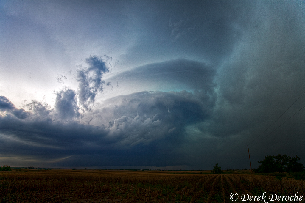
5/29 Glen Elder, KS/Kearney, NE Chased with a plethora of folks during the course of the day including Blair, Burtis, Pietrycha, Magliocco, and Fritchie observing two tornados and incredible structure across southern NE/northern KS. Began the day in Kearney, NE with CI taking shape across NW KS/SW NE. Intercepted the first cell southwest of Elwood and followed it back toward the Kearney area, pulling east of it as it approached the city with incredible storm structure taking shape. A bowl shaped lowering developed at this point, with occasional power flashes and dust/debris witnessed as it moved through Kearney. As the storm moved east, it became fairly wet, taking on hp characteristics. Decided to abandon this area and make a dash south for activity across northern KS. Eventually caught up with the storm which moved from Stockton to Osborne, west of Beloit. Observed a multiple vortex tornado which moved close to the town of Glen Elder taking on many shapes through its lifecylce. For all practical purposes, ended the chase at this time as the storm raced off to the northeast. |
|
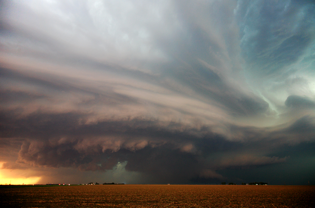
6/01 Julesburg, CO Katie Burtis and I observed great structure with the picturesque Julesburg supercell. We initiallyI targeted near Sidney, NE to start the day watching a couple of towers struggle early on in the vicinity. Met up with Bob Fritchie and Steve Vanderburg here and decided to intercept the cell which had been pulsing near Bridgeport. We soon found a nice view of the updraft region with a decent wall cloud developing NW of Dalton. However, a fairly cold RFD surge quickly wrapped around and squashed any tornadic chances. After observing a few additional RFD surges, we decided to head south for some structure opportunities and was pleasantly surprised at what this storm had become. Very photogenic striations developed as we neared Julesburg with laminar tail eventually feeding in as sunset approached. The lower light angle produced vivid color saturation on the west side of the tilted updraft region. Also of interest was the development of eddies rotating around the outskirts of the meso. Possibly some Kelvin-Helmholtz activity? |
|
|
6/02 Burlington, CO Leisurely chase today for Katie Burtis and I beginning the day in GLD with the plan to play the Palmer Divide. Departed around noon and stopped in Burlington to grab a drink and peruse data for a while. As this occurred, observed towering cu just off to the west so decided to keep an eye on it hoping it would have enough to overcome the stout cap. Soon enough, a full fledged supercell developed so we dropped south and east to keep ahead of it. The storm displayed impressive structure for a time with well striated updraft and several laminar tails streaming in. Hearing reports of softball to grapefruit sized hail and observing little signs of tornado potential, decided to drop south for some structure shots. However, as quickly as it developed, it seemed to fizzle as it approached GLD. |
|
 |
6/04 Maywood, NE Katie Burtis and I departed GLD originally targeting Russell where we met up with Scott Blair and Amos Magliocco. However we soon realized the cap presented a potential bust so we quickly readjusted to SW Nebraska for the ongoing convection. We observed three supercell across this area, intercepting the first storm near Elwood, NE. However, it quickly became outflow dominant and we abandoned this storm. We opted to head westward to intercept the persistent activity heading out of NE CO into SW NE. Struggling with poor dirt road conditions, we waited for the storm near Hayes Center, NE to approach our location along Hwy 83 south of Maywood, NE. We observed great mid level structure with this storm as well as verifying 2.50" hail in the vault region. In addition, as the storm moved east of our location, we had the opportunity to witness the alignment of the 3 left split updrafts. We observed a final supercell in the vicinity of the previous storm along Hwy 83 just after twilight. We verified 3" diameter hail with this storm as it crossed an abandoned Hwy 83 as well as impressive structure. |
|
6/10 Lawrence,KS Didn't plan to chase this day, however a storm developed by mid afternoon near Council Grove, KS moving northeast toward Topeka. Met up with Scott Blair as the storm crossed I-70 but by this time it was much weaker. Observed dime sized hail as it moved north of the interstate along with some picturesque shots as the sun lowered behind the storm. Decided to set up for some sunset opps just east of Lawrence, KS and was treated to some nicely saturated cloud elements as the storms continued to decay. About this time a supercell developed off to the west near Hill City with the anvil quickly spreading eastward. The underside of the anvil glowed bright yellow/orange at sunset illuminating the sky for quite a while. |
|
 |
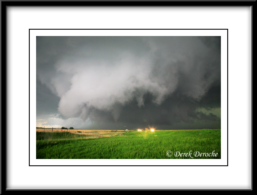
6/11 Hitschmann/Chapman, KS Scott Blair and I observed two tornadoes, the first near Hitschmann and the other near Chapman. We intercepted the initial supercell south of Susank, KS observing very rapid rotation in the cloud base from approximately 2 miles east of Hitschmann, KS. A tornado quickly developed as a well-defined dust whirl beneath the persistent funnel. The tornado transitioned into a multi-vortex structure as it moved east of our location. The tornado wrapped in rain, but eventually remereged as a condensed cone near the Barton/Ellsworth county line. We followed the storm to I-70 as it decayed. We then dropped back south on, at the time, tail end charlie. Phenominal structure was observed with this supercell near Holyrood just before sunset. Several dust whirls were observed with this storm, howerver, visual tornadoes could not be confirmed. We intercepted one final supercell and tornado along I-70 after dark near Chapman, KS. with several power flashes. This tornado was eventually rated a strong EF-3 tornado as it moved through Chapman. |