Chase
Accounts
Click On Image For Additional Photos
2009
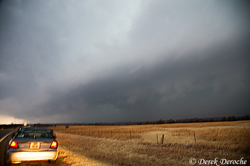 |
2/10 Pawhuska, OK With an unexpected early initiation, got a late start on the day and missed the central OK action. Blair and I eventaully made it to the KS/OK border in an attemp to either intercept the long lived supercell moving out of central OK or any additional convection that may form on the leading edge of the theta e surge. We finally met up with the Gutherie, OK supercell as it neared Pawnee, OK. Around 5:30 pm, we stopped just south of Pawhuska, OK on Hwy99 and watched as the updraft base became visible. Decent mid-level (with some weak low-level) rotation briefly became evident within the notch region. Thereafter, the storm seemed to struggle as we followed it north of Bartlesville, OK where we encountered 1.5" hail. |
 |
2/26 Humansville, MO Returning from a trip to New Orleans, Katie Burtis and I departed Fort Smith, AR targeting an area from Joplin, MO to Nevada, MO. Met up with Blair and Leighton in Nevada as weak convection developed across northern into central MO. We decided to target the southern edge of convection which seemed to be located within the northern surge of theta e advection and the southern portion of the weaker inhibition. We headed east on Hwy 54 to just east of El Dorado Springs, MO observing decent low level struction and a pseudo fault region. We took Hwy 13 south and intercepted the storm as it crossed between Collins and Humansville. We observed 0.5” to 0.88” hail with a few as large as 1” in diameter as the core overtook our position. We left the storm thereafter, unwilling to fight the darkness and increasinly poor terrain. |
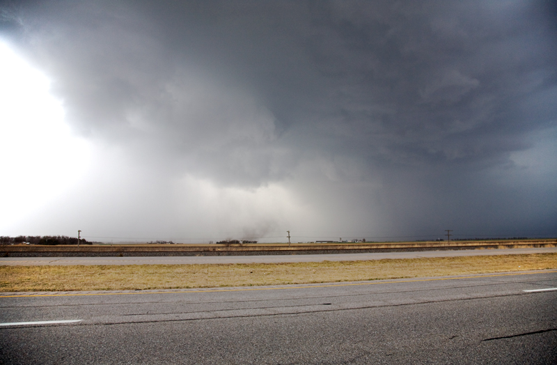 |
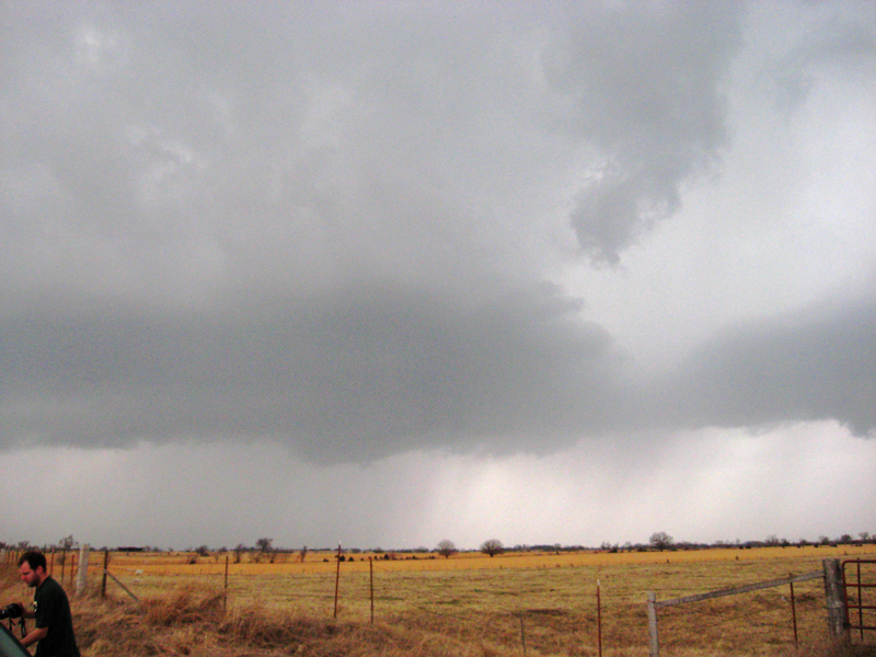
3/7 Partridge, KS Departed Goodland, KS with an initial target near Pratt, KS near the triple point as a developing sfc low began to eject into south central Kansas. Weak convection emenating from SW KS began to intensify as it interacted with deep low level moisture and a subsequent more unstable air mass as it approached St. John, KS. Soon after, the storm began to intensify rapidly, taking on supercell characteristics as it neared Abbyville, KS. Observed a tornado fairly early on in the storm's life cycle when it was just NW of Patridge. The entire formation occurred rapidly with an initial benign looking base but intensiying core. Soon after, a large chunk of scud developed and rapidly lifted beneath the updraft region with a dust bowl soon forming. The circulation then quickly tightened with rapid cloud base rotation above.
There was not enough evidence from my perspective to determine if there were additional "tornadic" circulations or if these were resulting from the RFD surge. I lost the updraft region as it passed through Hutchinson and caught back up with it prior to it crossing I 135. Ended the day observing dime to nickel sized hail south of Lawrence. |
|
3/23 Winfield, KS Burtis and I met up with Blair in LWC and headed toward south central Kansas near the anticipated dryline/cold front intersection. Enhanced cu soon developed near the dryline bulge near the OK/KS border with convection developing shortly after. A supercell eventually evolved near Kingman, KS with the updraft coming into view near Burrton. We followed it to Hesston, KS before letting it go as it seemed to struggle once it propagated off the dryline. Dropped south to a new storm near Medford, OK that appeared impressive via radar observations. About 5 miles east of Winfield, KS, we observed the approaching updraft to the southwest with a blocky wall cloud with wrapping rain soon coming into view. We then moved to near Cambridge, KS where a new area of rotation organized. However, precipitation soon wrapped around this region as well eliminating it from our view. One last updraft was observed to the northeast, south of Severy, KS along Hwy 400 with a brief moment of low level rotation before the storm became outflow dominant. |
|
|
3/30 Maple Hill, KS Met up with Blair in LWC to observe a line of elevated convection just west of Topeka. Exiting off I-70 at MM338 in between Paxico and Maple Hill, we observed semi-frequent lightning and surprising mammatus on the west side of the developing line. We then relocated ahead of the line on the west side of Lawrence, noticing an impressive 'whales-mouth' shelf cloud structure developing as we drove beneath. We were able to capture several lightning/structre stills before the line overtook our location. |
|
|
4/4 Lee's Summit, MO This day took me by surprise as a relaxing evening before a midnight shift was soon interupted by freuquent rumbles of thunder. I glanced outside to observe vivid white CGs and quickly headed out the door to some familiar foregrounds. The high based convection soon overtook my position so I relocated along MO Hwy 7, just south of MO Hwy. 50. The lightning frequency had diminished somewhat from the early activity, however there were enough visible strikes for a few keeper stills. |
|
|
4/9 Cedar Vale, KS Interesting forecast challenge in anticipation of this event as two potential targets seemed intriguing. The first area was near the occluding surface low west of ICT where significant low level vorticity was maximized beneath the upper level cold core. The second being near the nose of the dryline bulge where overall steep lapse rates were still in place along with higher llvl moisture values. Met up with Blair and decided to play the dryline option near Sedan, KS. We quickly got on developing convection along the KS/OK border, east of Arkansas City. This storm soon began to take on decent structure with rain-free base, large core, and occasional wall cloud development near Cedar Vale, KS to Grenola, KS. However, new upstream convection ingested into the storm disrupting its organization. The remainder of the convection this day struggled and quickly became outflow dominant. |
|
|
4/18 Burrton, KS Got a late start on the day as initial convection developed near DDC prior to 18Z. Initial target was near the anticipated llvl moisture tongue beneath the upper level cold core near the KS/OK border (just north of Alva, OK). However while en route near ICT, a small storm developed about 30 miles to the north near Mt. Hope. Since this storm was so close and theoretically within a similar atmospheric environment, I decided to take a look. My intial view revealed a fairly robust updraft tower as the low topped convection propaged north along a residual boundary. Met up with Blair just north of Burrton where we briefly observed benign llvl structure. With little overall motion beneath the updraft region, we decided to sample the hail size within the core. We positioned along CR785 about 8 miles N of Burrton where we observed copious amounts of nickel to quarter sized hail as the storm intensified over our location. We continued to observe and measure up to 1" hail near the intersection of CR556 and CR785. |